The prominence value for this mountain is 4288 feet
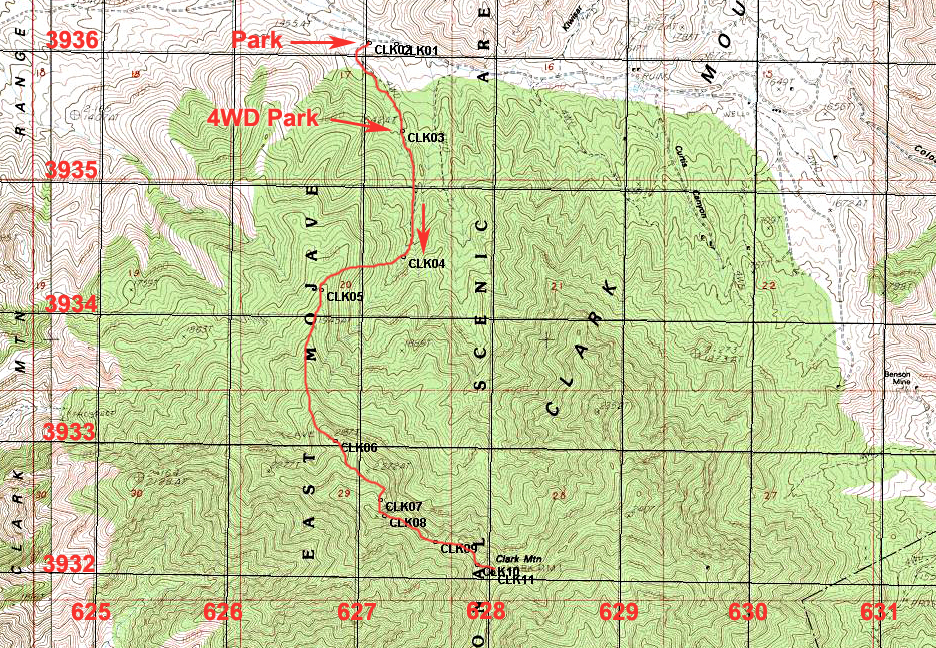
Driving Directions: On Interstate 15 take exit 272 at Cima Road. Go north on the paved Excelsior Mine Road for 8.8 miles and then turn right (east) onto a power line access road. Follow this for 6.2 miles and turn right onto a dirt road at point CLK00 which is north and off the above map. Follow this south for 2.5 miles and make a sharp right. A four-wheel drive vehicle may be needed from here. Drive about 0.1 miles and turn left. Follow this road south about 0.6 miles until it ends at a wilderness boundary sign at point CLK03.
Hiking Route: Follow the old road south to its end at point CLK04. From there go west up a slope to a ridge line at CLK05. Follow this ridge which is mostly easy going except for a rocky section at CLK06 until you reach the highpoint at about 7780 ft. at CLK08. From here the summit is visible and is 0.42 miles on a bearing of 109 degrees true. Descend the steep face just to the right of the ridge top and head along the ridge. Waypoint CLK09 is a low point which has rough side-hill travel. As the ridge ends go right around a knife-edge rib coming down from the summit and climb up by a large pine tree. This point is at CLK10. Most other chutes do not work so be sure to go by this tree. Once above the tree you can make your way to a good chute that leads to the top. Close to the top go up a narrow chute to the summit. This route is about 6.6 miles round-trip with an elevation change of about 2800 ft. Due to some loss on the ascent I estimate the overall gain at about 3100 ft. Allow about nine hours for the hike. 11/03 RLC