In the Anza-Borrego Desert State Park
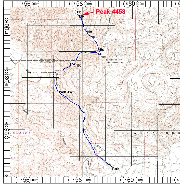
Driving Directions: From the Christmas Circle in Borrego Springs drive east on Borrego Springs Road which is route S22. The highway passes the airport then goes north past Pegleg Historical Marker and then east toward the Salton Sea. At 1/2 mile east of Pegleg turn left (north) on signed Rockhouse Trail which is paved for a very short distance then turns into graded dirt. The road has a lot of washboard surface, but otherwise is good for most any high-clearance vehicle. A short section crosses the Clark Dry Lake and it is best not to drive this if there has been recent rain. At about 8.8 miles there is a junction and sign for Butler Canyon. Go right here. We stopped at the PARK location where the road dipped into a wash with many big boulders. A 4WD vehicle with high clearance is needed beyond this point. More adventurous drivers can drive another 2.9 miles to the PARK, 4WD location which is the wilderness boundary. There is plenty of turnaround space and room to camp there.
Hiking Directions: If you stopped at the 2WD PARK location you will have a 2.9 mile walk on a sandy road to the 4WD trailhead. From there head northeast into Rockhouse Canyon. The walking is easy until point 105 where a 20 foot dry waterfall is located. It is a scramble on the right side to get past this obstacle to where the wash is easy once again. At point 106 there is a sharp bend and we headed north up the slopes. The ridge is good except for some steep, rocky terrain between points 108 to 109. It is a 2100 foot climb from point 106 to the summit which takes about two hours. There is a register and Terra Cache at the summit. The northern rounded summit (point 111) is about 580 feet away and is nearly the same height. Our simple hand level was not conclusive. Peak4458 GPX file
Stats: From the 2WD PARK location the hike is 13.8 miles round-trip with a gain of 3200 feet. Allow about 4 1/2 hours up and 4 hours down. If you can get to the 4WD trailhead that will cut off 600 feet of gain and 5.8 miles. The drive in is slow and takes up to an hour from S22 to the 4WD trailhead. In the winter months get an early start. 1/14 RLC