In the Toiyabe National Forest, Elevation = 9808 ft. (2990 meters)
Located in the Monitor Range
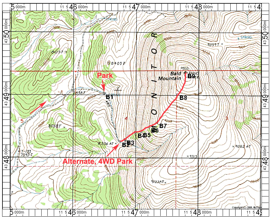
Driving Directions: From route 50 about 40 miles east of Austin, take the Monitor Valley Road south. The road is close to a rest area. Drive 14.5 miles south and turn east. This junction has a sign indication it is at the Geographic Center of Nevada. The road east is 43004. Drive 7.8 miles entering Wallace Canyon and reach a junction. The road east is 23216, the four-wheel drive route to Summit Mountain. Turn right on 43004 which goes up over a saddle in a 100 yards which makes a good camping area. Head south on the fairly good dirt road suitable for most high-clearance vehicles, then east and go left at junctions in about 2.2 and 3.3 miles. At 4.7 miles go left at another junction. At 6.2 miles go right and park at a corral at 6.6 miles. With a four-wheel drive vehicle you can continue a half mile more.
Hiking Route: The hike is very simple as shown by the red line on the map above. Stay on the ridge and go left somewhat around trees part way up. The climb is 1500 ft. with a round-trip distance of 2 miles. The map has a one kilometer UTM grid using NAD 27. A gpx route file is available: BaldMtn.gpx. The benchmark was there, but I did not get a photo. Datasheet.